Ice edge mapping
High-resolution ice edge mapping by Synthetic Aperture Radar (SAR)
An automatic procedure for Radarsat-2 data processing and daily mapping of ice in the Barents Sea (around Svalbard) at 1 km spatial resolution has been developed and run autonomously. Radarsat-2 data available within the MyOcean2 project are downloaded from the GMES Data WareHouse (DWH) to a server at NERSC, uncompressed and processed first at Level 2 (image-per-image ice/water classification) and then at Level 3 (daily maps generation). We use data from Radarsat-2 received in ScanSAR Wide (SCW) mode at dual-polarization, i.e. HH (horizontally transmitted and horizontally received) and HV (horizontally transmitted, vertically received).
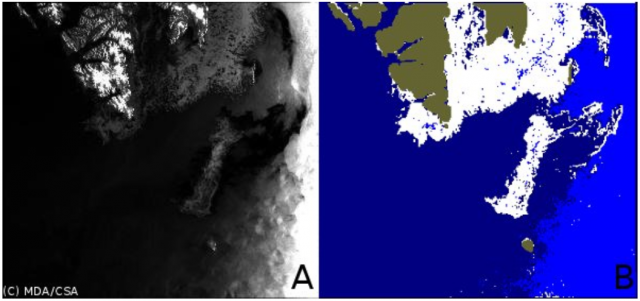
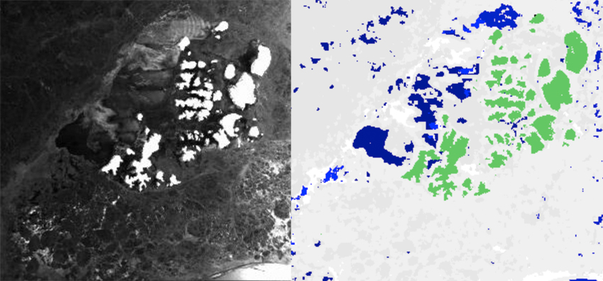
A non-linear scheme for classification of Radarsat-2 data has been developed. The processing allows us to identify three classes: ice, calm water and rough water at 1 km spatial resolution. The raw sigma0 data in HH and HV polarization is used for computing texture characteristics in a moving window using a Gray Level Co-occurrence Matrix (GLCM). A neural network is applied at the next step for processing array of the most informative texture characteristics and ice/water classification. An example of ice-water discrimination is shown in Figure 1. During the course of the project, the classification algorithm was modified to use Support Vector Machine (SVM) techniques. An example of ice-water discrimination using the new algorithm is shown in Figure 2.

Figure 1:
An example of Radarsat-2 image (A) classification (B) into ice (white), calm water (dark blue) and rough water (blue). Greenish color masks land (Svalbard on top and Bear Island near bottom on this image). ©NERSC/NIERSC

Figure 2:
Ice water discrimination from Radarsat-2 images in Franz Josef Land archipelago on 03 April 2013. Left: ScanSAR wide swath image in dual polarization, HH and HV. Right: classified image using classification algorithm, where bright grey is sea ice, blue is water and green is land.
The products are produced every day and are available on http://web.nersc.no/project/maires/catalog.php.
